
Why the 2024 Hurricane Season is Expected to be so Wild
Higher global and ocean temperatures alongside weakened wind shear have the potential to create a very busy – and potentially very dangerous – Atlantic hurricane season.
5 min read
SHARE


The 2024 Atlantic hurricane season just kicked off on June 1 – and climate scientists and meteorologists agree that it’s looking like a doozy.
Forecasters at the National Oceanic and Atmospheric Administration (NOAA) predict “above-normal hurricane activity” in the Atlantic this year. How sure are they? Pretty sure: NOAA is giving it an 85% chance of being an above-normal season.
But what does “above normal” mean here? NOAA is forecasting that this year’s hurricane season, which continues through November 30, could include “17 to 25 total named storms (winds of 39 mph or higher). Of those, 8 to 13 are forecast to become hurricanes (winds of 74 mph or higher), including 4 to 7 major hurricanes (category 3, 4 or 5; with winds of 111 mph or higher).”
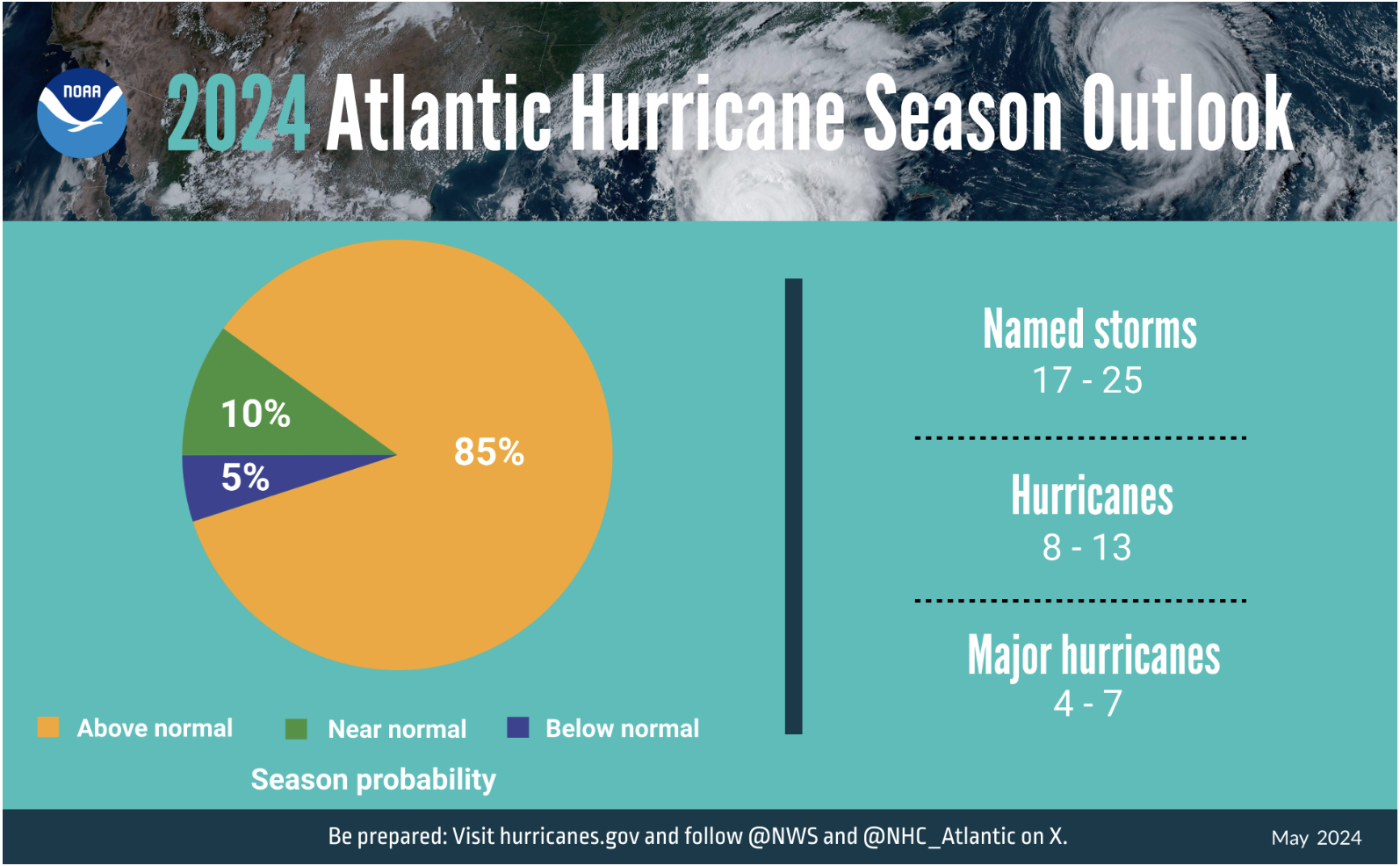
Image credit: NOAA
In recent years, we’ve seen more and more powerful storms forming in the Atlantic, including mega-storms like hurricanes Fiona, Harvey, Irma, and Matthew. Rapid intensification of storms has increasingly become the norm too.
So what sets 2024 apart from the last few years? A couple of factors.
The Atlantic is Hot, Hot, Hot
And when we say hot, we mean hot.
Sea-surface temperatures are well above historical averages across much of the Atlantic Ocean basin, including in the Gulf of Mexico, the Caribbean, and off the western coast of Africa, where many tropical storms first develop.
In May, the Caribbean was averaging temperatures as high as 84.7 degrees Fahrenheit, a staggering temperature more likely to be seen in August than May. Temperatures are expected to climb from there through the summer months too, with the potential to continue setting records.
For the broader north Atlantic, the average temperature was 2.34 degrees Fahrenheit above the 1982-2011 mean, reaching 72.14 degrees Fahrenheit as we entered June. And in the “main development region” for Atlantic tropical cyclones, sea surface temperatures are 2.52 Fahrenheit degrees above the 1991-2020 average.
Why are sea surface temperatures so important when we’re talking about the strength and number of tropical storms and hurricanes? Because warm water fuels tropical storm systems.
In fact, there’s about a 10-mile-per-hour increase in sustained peak winds of Category 5 storms for each degree Fahrenheit of ocean warming.
And the primary cause of all this heat? Human-created climate change.
“One of the most important factors behind the underwater heat wave is that humans have raised Earth’s average temperature by 2.3 degrees Fahrenheit since the dawn of the Industrial Revolution by burning fossil fuels and emitting heat-trapping gasses,” Vox writes. “The vast majority of the warming — 90 percent — is occurring in the ocean.”
The El Nino Factor
While the current extreme heat in the Atlantic can largely be attributed to climate change, it’s been made even worse by a different weather phenomenon: El Nino.
If you’re thinking, “Isn’t El Nino so six months ago?” or “Wasn’t that in the Pacific Ocean?” you’re not wrong.
But the thing with El Nino is that it doesn’t exactly go quietly into the night. Its effects can be felt around the world long after the event itself has faded into the rearview – mostly in the form of lasting elevated global temperatures, more broadly.
Human-caused global warming, together with El Nino-related heating, helped make 2023 the hottest year on record. And with the warming attributed to El Nino expected to stick around for a bit, it’s a trend that will likely continue throughout 2024 – January, February, March, and April of this year have all been the hottest of each month on record, respectively – even as we likely enter into a La Nina cycle (more on her impact in a minute).
As the world becomes warmer, naturally, more water evaporates from our oceans. That’s just how evaporation works. It’s a circumstance complicated by the fact that warmer air also holds more moisture.
Taken together, these factors mean there’s more water vapor for hurricanes to suck up as they travel over the sea surface, and more capacity to hold on to it. So when they make landfall, all that extra moisture returns to the earth’s surface as heavy precipitation.
What About La Nina?
Oh, her? She’s got a role to play here too.
El Nino conditions, when ocean temps in the eastern Pacific are elevated above normal, now seem to be transitioning to a La Nina pattern, where ocean temps fall below long-term historical averages.
“La Niña could form as early as June-August 2024, with higher confidence of La Niña during the following seasons,” NOAA’s Climate Prediction Center writes. “La Niña generally tends to follow strong El Niño events.”
This transition is expected to have major implications for the Atlantic basin.
La Nina typically reduces strong high-altitude winds, also called “wind shear,” across the Atlantic Ocean basin. This reduction in wind shear is a godsend to hurricane formation. Why?
“Strong upper level winds destroy the storm's structure by displacing the warm temperatures above the eye and limiting the vertical accent of air parcels,” according to the National Weather Service. “Hurricanes will not form when the upper-level winds are too strong.”
But when they're weak, it's another story entirely. Put simply: When upper-level winds aren’t as strong, as is likely in the Atlantic in a La Nina period, it has the potential to allow more storms than usual to form.
A Busy Season
Higher global and ocean temperatures from human-caused global warming and residual effects of El Nino alongside weakened wind shear caused by La Nina have the potential to create a very busy – and potentially very dangerous – Atlantic hurricane season.
It’s our hope that this early warning will give folks that may be threatened by these potential storms – from the islands of the Caribbean to the Atlantic and Gulf coasts of the US and Mexico and beyond – the time to prepare as best they can for the months ahead.
At Climate Reality, we’re working hard to bring an end to the era of fossil fuels – and with it the climate crisis that is driving extreme weather like this all around the world.
It’s our responsibility to do everything we can to prevent the worst of it. And it certainly could get much worse.
Be sure to share this blog post widely with your networks, so your friends and family in regions that might be impacted by the coming Atlantic hurricane season can be ready if trouble comes knocking.


