Climate TRACE: An invaluable tool for the climate movement
Combining machine learning, satellite data, and artificial intelligence, Climate TRACE gives advocates and decisionmakers the detailed emissions information to act.
5 min read
What is Climate TRACE?
To measure progress toward our Paris Agreement climate goals, it’s more important than ever to have accurate greenhouse gas emissions data. Not just to hold governments and businesses accountable for their climate commitments, but also to identify the biggest emitters holding us back.
For far too long, we’ve had to rely primarily on lackluster self-reporting to evaluate progress on climate goals. So, in 2020, former US Vice President Al Gore co-founded the non-profit Climate TRACE to help fill this gap in global emissions data. Using new advancements in technologies like machine learning, artificial intelligence, and satellite imagery, Climate TRACE can analyze massive amounts of information, pinpoint emissions sources, and ultimately calculate emissions with incredible detail.
How Can I Use Climate TRACE?
Climate TRACE distills information from over 300 satellites, more than 11,000 sensors, and many other resources, to provide transparent and accessible emissions data for anyone to see — including you! Climate TRACE’s data is free and publicly available at climatetrace.org.
Are you curious to learn more about the major sources of greenhouse gas emissions in your area? Climate TRACE has an interactive Emissions Map that allows users to explore greenhouse gas sources around the globe.
To show how this works, let’s explore emissions data in Italy (the location of our recent Climate Reality Leadership Training in Rome).
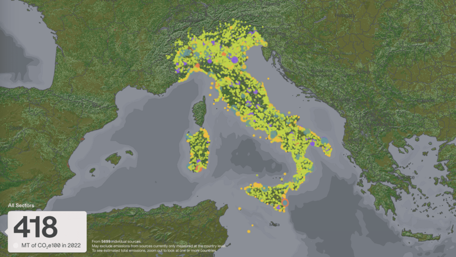
Using the platform’s map, we’re able to look at an individual country (or countries) and visualize individual sources of emissions, color-coded by sector.
According to Climate TRACE, emissions from Italy were 418 MT of CO2e100 or million tonnes of carbon dioxide equivalent (the measure of all greenhouse gases combined) in 2022. This includes (but is not limited to) emissions from 5,696 individual sources tracked by Climate TRACE.
If we wanted to look specifically at fossil fuel operations in Italy, we can select that category (under Sector in the search toolbar) and examine emissions from coal mining, oil and gas refining, oil and gas production and transport, and more. That narrows the scope of our search down to 14 sources that Climate TRACE has identified.
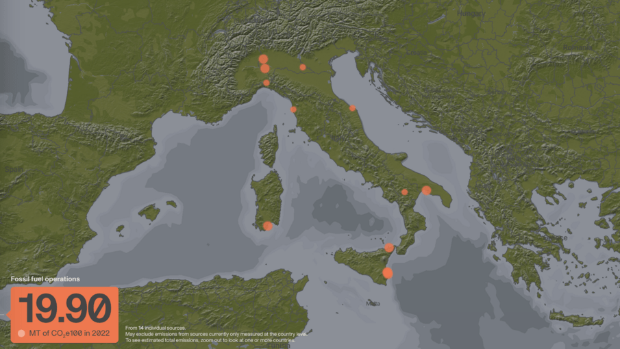
From there, we can click on a specific site to learn more, including the type it is (for example an oil vs. gas field), the activity level of the facility (i.e. barrels produced per day for a refinery), and information on the facility owners or operators of those facilities, where available.
For example, we can see that in the category of “Fossil Fuel Operations,” the facility with the highest emissions in Italy is the Saras SPA Sarroch Oil Refinery. Climate TRACE gives us data on that specific refinery and others in the country.
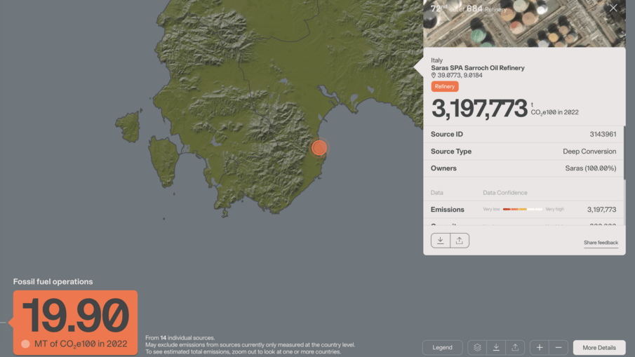
Climate TRACE also provides transparency on the confidence it has in the emissions estimates for each facility via “Data Confidence.” This is based on a number of factors that make it easier or harder to detect emissions-causing operations from space or other market data.
Zooming in on Emissions from Specific Sectors
We can also use the map to analyze the top sources of emissions from a specific sector – either globally or within a particular country or region.
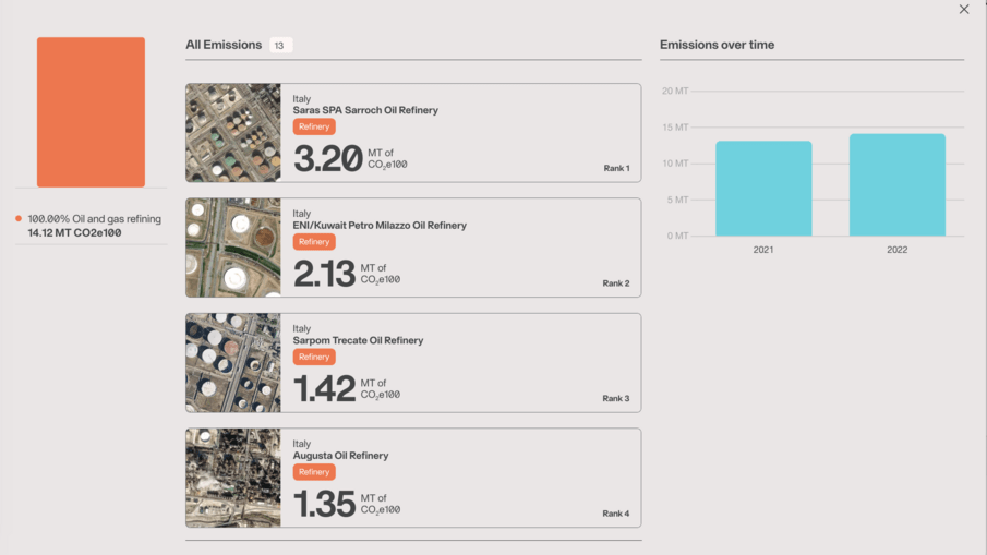
Staying in Italy, let’s look at the fossil fuel operations sector. With so many refineries in the country (13 out of the 14 fossil fuel sources total in Italy’s Climate TRACE inventory), it can be helpful to look through the emitters as a ranked list.
Click on “More Details” in the bottom-right, and we see that the Saras SPA Sarroch Oil Refinery is the highest ranked asset in Climate TRACE’s data on the Italian oil and gas refineries, producing 3.20 MT of CO2e100 in 2022.Not only can we easily see how this facility ranks in relation to other power stations in the country, we can also see a bar graph showing how total power emissions in Italy have changed since the previous year. In this case, between 2021 and 2022, emissions increased.
Charting National Progress
As we look to COP29 in Azerbaijan this fall, the Climate TRACE inventory can show where countries rank in overall emissions and where they’re making progress or lagging behind.
On Climate TRACE’s Country Inventory page, we can see that Azerbaijan ranks 59th in terms of global emissions in 2022 while Italy, the location of our recent Climate Reality Leadership Training, ranks 27th. Along with country-level emissions estimates, the tool shows how emissions have changed year-by-year since 2015 (overall and by sector) as well as per capita emissions figures.
We can also use the Comparison Tool to get even more detail. In addition to comparing country or sector totals, you can generate a list of individual emissions sources for any customized set of data across every country and every major industry. For example, you could pull up a list of the power plants covered by Climate TRACE in Azerbaijan, or look at the ranked list of the highest-emitting oil refineries in Europe. Once you have a list, the tool enables you to place it side-by-side with another customized selection to build your own comparison.
These interfaces help provide a snapshot of how emissions are rising and falling over time — and which facilities are the most significant contributors each year.
Why Is Climate TRACE Special?
While we know the total amount of carbon dioxide in the atmosphere, thanks to the Keeling Curve, it’s incredibly hard to determine where exactly it and other greenhouse gases are coming from.
Climate TRACE answers that need and gives advocates and decisionmakers the data to act using a combination of a massive amount of satellite data and AI to provide groundbreaking emissions information. As an independent and public database, TRACE fills an important gap in reliable information for anyone working toward climate solutions.
Are you ready to find the biggest sources of emissions in your area? Visit Climate TRACE and give it a try today.


